Police Scotland modernises search operations with geospatial technology
Wednesday, 23rd September, 2026
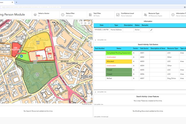
Missing Persons Dashboard Edinburgh
Police Scotland has modernised its search operations used to find missing persons, secure Royal visits and protect major events, using geospatial technology from Esri UK. Innovations include mobile mapping apps for field officers and interactive map dashboards for search advisers to direct operations, helping to improve decision-making and efficiency of security operations.
Replacing paper maps and hand-coloured search areas, the new approach is delivering better communication, real-time tasking of search teams and significant time and cost savings. Training for almost 300 users of the new applications has just been completed and the system was most recently used at the Commonwealth Games in Glasgow in July 2026.
Police Scotland has won an international Esri Special Achievement in GIS Award for its achievements, presented at Esri’s User Conference in San Diego, one of the world’s largest geospatial industry events with around 20,000 delegates. Winners are chosen by Esri President Jack Dangermond for setting new standards in the GIS (Geospatial Information System) community.
Covering more than 28,000 square miles across urban, rural, island and remote communities, Police Scotland has 23,000 officers and staff.
Inspector John Mackay, Search Coordinator, Police Scotland, said: “Search plays a critical role in keeping people safe from harm. By replacing complex paper-based processes with faster, streamlined digital workflows, we are helping officers make better decisions, deploy resources more effectively and deliver better outcomes for our communities. Police Scotland is incredibly proud to receive an Esri Special Achievement in GIS Award, recognising the significant progress the team has made in modernising search operations.”
Finding missing persons
The Missing Persons Module helps senior officers plan and allocate resources more efficiently, including assigning areas to either dog teams, horses, drones, diving and marine units, fingertip search or other specialist resources, including mountain rescue. Officers on the ground receive assignments and search boundaries on mobile devices so they know exactly where to search.
The system connects field teams and command staff instantly, improving coordination and decision making. Everyone sees the same updates, including images of finds such as recovered clothing so search strategies can be refined in real time. Search advisers can also support teams remotely, which is particularly valuable in Scotland’s remote and rugged areas.
Making locations safe
New Esri geospatial tools are helping to secure venues before major events or Royal visits. Officers use mobile devices for logging search and seal operations at locations such as drains, vents and lamp posts – potential hiding places for weapons or explosives – recording progress with photos. Often involving thousands of assets that need to be checked at speed, the approach allows search supervisors to maintain control. For high-profile visits by heads of state, teams use drone imagery and CAD drawings to create a more accurate operational picture with custom digital maps.
Police Scotland has also created virtual models of regularly searched locations, including Holyrood House and the Royal Mile in Edinburgh, speeding up checks by pre-recording known assets. Digital floor plans help divide buildings into sectors, allocate tasks and monitor progress if anything suspicious is found.
The recent developments in search at Police Scotland evolved from initial search and seal operations created for COP26 in 2022, the largest international summit the UK has over hosted, with 38,000 delegates. The scale and complexity of the Glasgow event made previous paper-based methods impractical. Esri geospatial tools meant operations were completed up to 75% faster, providing security with fewer resources.
Future plans
Police Scotland plans to increase drone use and continue developing 3D capabilities to give officers more context in operational views.
Chris Gardiner, Head of Public Safety at Esri UK, said: “The innovation achieved by Police Scotland is an outstanding example of how GIS can help keep communities safe. Traditionally only used by police data analysis teams, GIS is now an operational tool, supporting officers in the field with location intelligence to help locate missing people. Over 170,000 people go missing in the UK each year, estimated to cost UK policing £700m. Innovative approaches like this not only save lives but also improve productivity, saving time and money.”